
<p>Hurricanes may begin to strike the southern New England coastline more often and more ferociously than at any time since colonial settlement, according to a new study that offers evidence of ancient hurricane landfalls in the Northeast.
With the snow still banked high and morning temperatures flirting with zero, it might not be the best week to bring up the subject of tropical cyclones.
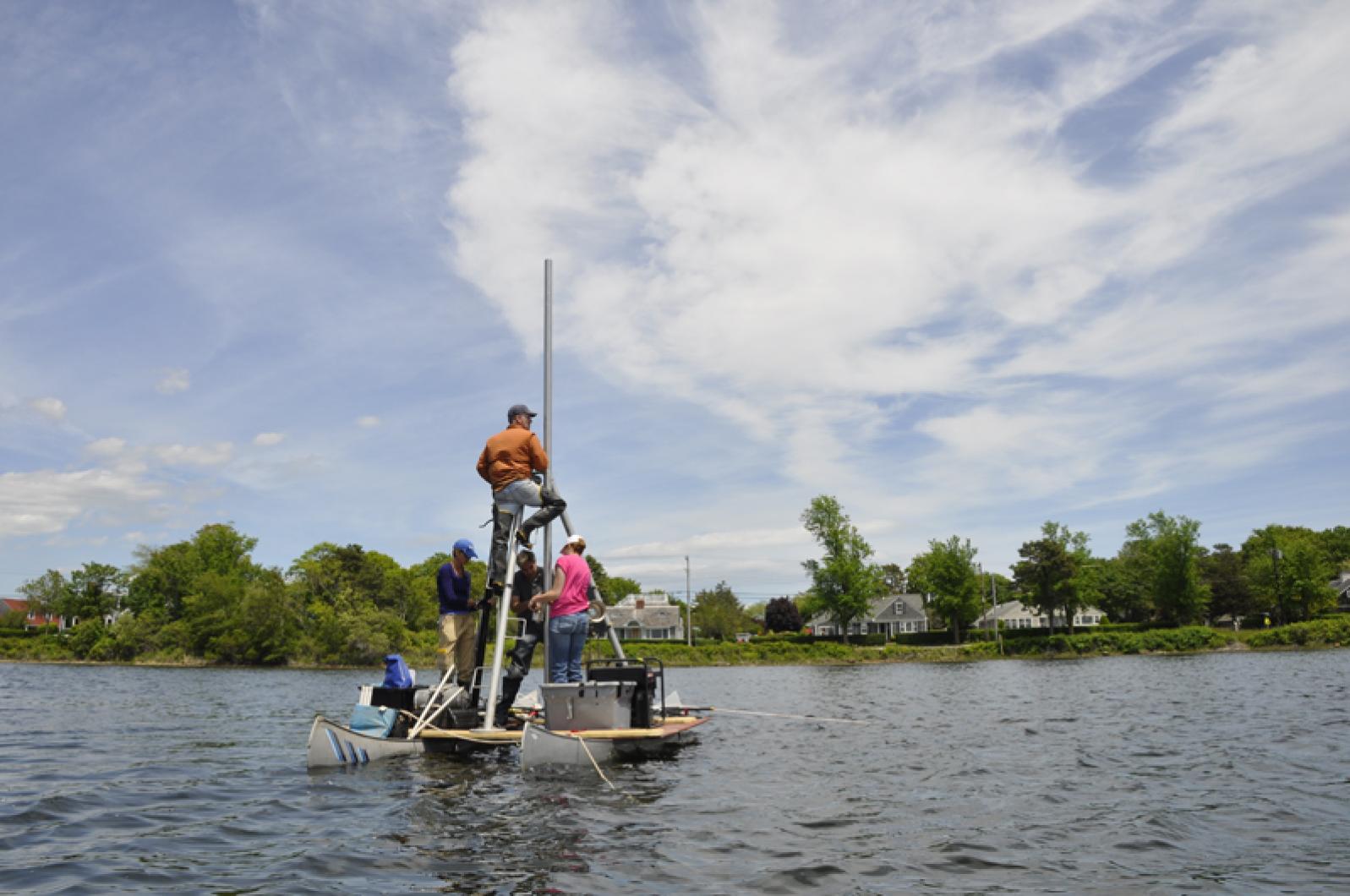
But hurricanes may begin to strike the southern New England coastline more often and more ferociously than at any time since colonial settlement, according to Jeff Donnelly, the lead scientist in a new study that offers evidence of ancient and mighty hurricane landfalls in the northeast. The research was conducted in a coastal pond just across Vineyard Sound in Falmouth.
With unprecedented specificity, the study examines how many prehistoric hurricanes managed to overwhelm a barrier beach that faces the sound, driving gravel, sand and other grit into the northern reaches of Salt Pond, which lies between Woods Hole and Falmouth harbor. Researchers counted 32 powerful hurricane strikes in the last 2,000 years. By contrast, the number in the last 400 years is just three.
The study focuses on long-ago time periods when sea surface temperatures in the tropical Atlantic and off the East Coast warmed substantially of their own accord, and it shows how hurricanes frequently formed and came up the seaboard to assail the northeast at the same intervals.
The critical point, Mr. Donnelly said, is that with the help of man, sea surface temperatures today already exceed those of the prehistoric past, and they continue to rise at rapid rates. Taking other meteorological factors into account, this suggests that hurricanes could begin to assault southeastern New England with at least as much frequency and catastrophic power as in centuries and millennia past.
“We’ve already surpassed these earlier intervals of warmth,” said Mr. Donnelly, who works with the geology and geophysics department of the Woods Hole Oceanographic Institution. “That’s only happened in the last decade or two. The rate of change is much greater than previously, and we’ve blown right past these earlier intervals of warmth.”
He added: “The grand experiment has begun.”
The study, called Climate Forcing of Unprecedented Intense-Hurricane Activity in the Last 2,000 years, was published Monday in Earth’s Future, an online journal published by the American Geophysical Union. Mr. Donnelly is a pioneer in the effort to find and evaluate layers of sediment that were washed over barrier beaches and into the bottoms of coastal wetlands and ponds by the storm surges of hurricanes in distant times.
“This particular study provided the most detailed and longest record from the northeast,” the scientist said. “We had similar records from the Gulf of Mexico and some from the Caribbean and the Bahamas, but none from the Northeast until this particular study.”
Up to now, core samples of sediments raised from northeastern ponds and marshes sometimes failed to delineate old-world hurricanes that made landfall decades apart. “Whereas with this record we can actually distinguish storms that happened just a year apart,” Mr. Donnelly said. Hurricanes that recently read as one storm at nearby coastal sites break down into six or seven at Salt Pond.
By examining layers of organic muck, as well as lead pollution from the start of the industrial age and even evidence of nuclear weapons testing, researchers can date the strata of sediments that hurricanes deposited above and below these other layers. In the new Salt Pond study, scientists do this more specifically than ever before. For example, sediment from the New England Hurricane of 1675 was spread just above rye pollen planted by the first colonists in Falmouth.
“To find the actual rye pollen that the settlers planted after they cleared landscape, and put a really precise date on that particular interval, allowed us to date that 1675 layer with much more confidence,” Mr. Donnelly said. “It’s pretty neat. Not only that, we also found some maize pollen from the Native Americans prior to that.”
Since the middle of the 19th century, hurricanes of category two (96 to 100 m.p.h.) or greater have savaged New England about once per century. That average now appears to be deceptively low. “When you get back to the prehistoric record, its much greater. You’re looking, at times, at three or even four storms per century,” Mr. Donnelly said. These intervals of much greater activity include the first millennium, between the years 150 and 1150, and again between 1400 and 1675.
Both were times when sea surface temperatures warmed appreciably due to cycles in nature. The earlier warming occurred across the tropical Atlantic between Africa and the Caribbean, considered the main development region for many hurricanes. The second happened off the southeastern coastline of what is now the United States, after the tropical Atlantic had cooled. This is where Hurricane Bob, the last category two hurricane to strike southern New England, formed in August 1991.
Though the study demonstrates how precisely scientists can now count prehistoric hurricanes in the right location, and link them to intervals of sea surface temperature warming, it is harder to measure how strong each Salt Pond tempest actually was. An ancient deposit might have been left by a vast and cataclysmic hurricane striking many miles away or a smaller and slightly weaker one scoring a direct hit. But to transport gravel and sand to the most inland ends of Salt Pond, where the core samples were all taken, suggests most of these long-ago hurricanes were exceedingly strong, Mr. Donnelly said.
“At least at first blush, when we [determine] the amount of course material transported, many of these storms were able to transport much more material than [more recent] storms,” he said. “And they probably did it over a greater distance, because sea level has been rising. Currently they have to be transported 400 metres to where the core was taken. In the past, because sea level was lower and the shoreline was farther out, they probably had to be transported 600 metres.”
With sea surface temperatures now warmer than any period covered by the Salt Pond study, and projected to warm further as the climate changes during this century, Mr. Donnelly said he hopes New England will prepare itself for hurricanes more frequent and more intense than anything people have experienced today, and even anything in the written record.
The nature of historic New England hurricanes is that they can form nearby, strengthen rapidly, hybridize with other weather systems and hurtle northward at highway speeds, causing immense damage to the east of the eye, where the forward motion of the storm is added to the wind speed around the core. These qualities were probably also true of coastal hurricanes hundreds and thousands of years ago, Mr. Donnelly said.
“Storms coming up the eastern seaboard at 50 or 60 miles an hour — that means we only have eight hours or so between the storm being off the Outer Banks of North Carolina and it making landfall in southern New England. We don’t have a heck of a lot of time to react and make sure that people are out of harm’s way,” he said.
Hurricane Sandy in 2012 doesn’t offer a good comparison, he added. It was large and struck New York and New Jersey at high tide. But it was weak and slow moving and still caused more than $60 billion in damages. Dr. Donnelly looked to the near and distant past this week and offered a different analogy: “Even if we don’t see a return to these earlier intervals of activity, even if we [only] have a return to what we experienced in the middle part of the 20th century, we’re in some serious trouble,” he said. “We’ve got storms like 1938 and Hurricane Carol in 1954 impacting a region that has much more development — and the sea is another foot higher than it was when we were hit in 1938.”
Comments
Thanks for giving the
deshandra brown mvThanks for giving the insurance companies another reason to raise my rates. These 'studies and predictions' have been used for 30 years to stick it to the homeowners on Martha's Vineyard, Nantucket, and Cape Cod with higher rates. Despite the fact the most damage from hurricanes is flood related (and therefore NOT covered by homeowner's insurance), the state regulators have turned a blind eye and allowed the property/casualty insurers to pull out of this area, and the ones that haven't have raised rates to astronomical levels. We pay 4x here what our off-island home costs, despite no losses in the 30 years we have had it. The off island home is in an area clobbered by superstorm sandy, yet the rates remain at about 25% of what we pay here. The elected state senators are not doing their job by allowing insurances companies to 'cherry pick' who the will insure in Mass. If they did it in the inner cities, I'd expect there to be an outcry. Btw, the "Fair plan' was created when no companies would insure in the inner cities due to crime, riots, etc... Now many people here are forced into this overpriced plan as the insurance companies 'cherry pick' the policies, thanks to these sort of reports. By the way... all of these 'studies' since hurricane bob have proved to be pure BS.
I agree with Deshandra that
Paulli D EdgartownI agree with Deshandra that these so called studies are BS and that the insurance companies use this baloney to justify their higher rates. I have been through 3 so called hurricanes on MV which have been mostly wind and nothing more. While I do understand that these are not direct hits, this constant 'it's going to happen' scenario has to stop. Sure in the next 10, 20 or 30 years we will get hit, but these studies always make it sound like 'this is the year'. Stop this please so that we can insure our home at affordable rates. If you want to study something, find our why politicians keep raising taxes but NOTHING gets fixed. That could take decades to resolve.
It is sad when careful,
Bruce Nevin 101 Chase Road, EdgartownIt is sad when careful, detailed scientific research is dismissed as BS, and the only thought that comes up is the insurance bill. ///
Insurance was not originally conceived as a for-profit business, but rather as a kind of shared savings account, money put aside to cover risks and hazards to property, health, or life itself. Managers and actuaries were responsible only to the pool of participants. The cost of coverage goes up when the potential cost of the covered risks goes up. But today insurance costs more than that, and the reason is that insurance is now a for-profit business with primary responsibility to its shareholders. We policy holders are now a business liability, a cost of doing business. ///
We probably can't change this, not in today's so-called 'free' market climate, but as Deshandra Brown says we can tell legislators that we want insurance companies to be more responsive to us, we who are pooling our financial resources against that proverbial 'rainy day', and less responsive to their owners.///
And do put some thought and effort into arranging your home to survive high winds and high water. It may not be this year, or next, but it will happen.
For the past 30 years every
deshandra brown mvFor the past 30 years every 'scientific model' stated we were due for the 'big one' and would be getting a 'direct hit' the year of the study. History proves this 'detailed scientific research' is PURE BS. Will we ever get hit with a hurricane? Of course the probability exists. But there is a huge difference between science and an opinion with no scientific basis. How about the insurance companies pay us back for the excess gouging of the past 30 years, since their rates were based upon the junk science that fit their need to justify raising rates. Unfortunately the legislators could care less about the constituents, and due to the redistricting years ago, the Cape/Island's is a very weak district, and should have more legislators than we do. If our elected representatives had any clout, we would not be in this position of being forced into the 'fair plan'. Thankfully I'm not in it-and would never allow my agent to put me there. And you are correct to prepare for wind.*like the storm 2 weeks ago* I don't know how you can prepare against a flood tide if you built your home on a wetland or too close to the ocean.
Given the current popular
Robert EdgartownGiven the current popular climate change dogma, it isn't possible that these studies and the conclusions are correct! No,no, the climate couldn't have produced more storms before we began using fossil fuels. Well, maybe, just maybe the climate has been changing since the last ice age ( current winter is an anommaly) all on its own natural rhythm . And, our contribution is not the driving force? So, what now? How about we make smart choices and just try to get along in this beautiful place we live in........Don't build houses where they will get washed away. If you do don't expect the rest of to subsidize your choice. If you drive around the island the original homes were built high and dry and you took care of your own. Where did that New England ethos go?
Add new comment