

From the Chappaquiddick Point to the cranberry bogs in Aquinnah, new forecasts show that no part of the Island will be immune from the impacts of sea level rise.
From the Chappaquiddick Point to the cranberry bogs in Aquinnah, new forecasts show that no part of the Island will be immune from the impacts of sea level rise. New maps showing a drastically different Island coastline are part of the Vineyard Conservation Society’s Rising Seas Awareness Project. The maps will be shown and discussed at a talk tonight hosted by the All-Island Selectmen’s Association. The speakers are VCS board member Phil Henderson and Steve McKenna, a regional planner for the state Coastal Zone Management program. The theme is cooperation and planning to help soften the impact on the Island’s infrastructure and economy.
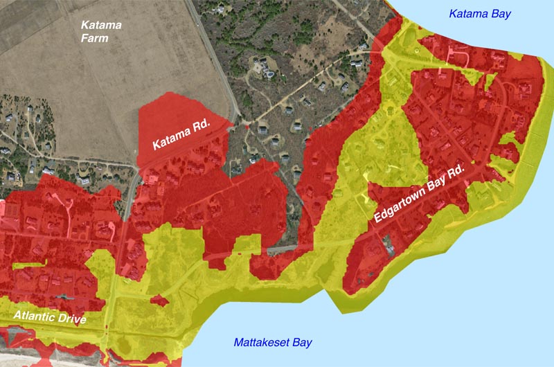
Created by the Martha’s Vineyard Commission and staff cartographer Chris Seidel, the maps show the estimated sea level rise on the Vineyard based on the International Panel on Climate Change’s “high” forecast for greenhouse emissions and other factors.
The maps show two different levels of sea rise: the first level of three feet and three inches is forecast to happen between 2050 and 2070, according to the presentation. An additional metre of sea level rise, or six feet and seven inches, is estimated to happen between 2100 and 2120.
The maps do not show flooding from high tides or storm surges.
According to the maps, by the beginning of the next century, water could nearly surround the Martha’s Vineyard Hospital, and most of Beach Road could be flooded.
The Sunset Lake area of Oak Bluffs, including down Dukes County avenue and halfway up School street, could also be under water, as could the Chappy point and both terminals for the Chappy Ferry. In Chilmark, coastal saltwater ponds would be pushed inland and barrier beaches reshaped.
One of the hardest hit areas in the early 2100s, according to the projections, would be Katama, where water could come inland as far as Katama Road and the southernmost field of Katama Farm. There are more than 100 homes in the potentially affected area.
The meeting begins at 7 p.m. Thursday at the Tisbury Senior Center.
For an in-depth look at the sea level rise maps, see our gallery: Vineyard Conservation Society's Rising Seas Awareness Project.
Comments
Very interesting piece, and
SCOTT R West Caldwell,NJVery interesting piece, and thank you!
I may be just missing it, but is there a key for the colors? Also, the link to the in-depth look at the maps project is not valid FYI.
Glad to see increased
John Englander FloridaGlad to see increased awareness about SLR. Many areas of the Vineyard will be affected. As a long time Vineyard resident of Chilmark in my youth, the Vineyard is a special place to me. My new book "High Tide On Main Street: Rising Sea Level and the Coming Coastal Crisis" explains the larger issue. With some pride I would like to mention that I end the book has a vignette from the Vineyard. For anyone interested it is available as all the e-book formats, and the printed version from Amazon. More information on my web site, johnenglander.net
As a kid & young man, I spent
Bill BostonAs a kid & young man, I spent many summer vacations at my folks' house on Edgartown Bay Road & have nothing but wonderful memories of that spot. I now live in Hull where we face the same issues. I won't be around for the 22nd century but the descendants of folks with houses still there may need to think about heading to higher ground. A mega-mansion underwater doesn't have much value, for any purpose.
Add new comment