

<p>The state Department of Transportation has finalized a $5.2 million renovation plan for the coastal roadway that runs along the Vineyard Haven waterfront.</p>
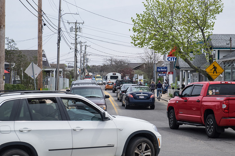
Beach Road. It is an Island lifeline, a main artery and also a nerve. After years of back and forth, the Massachusetts Department of Transportation has finalized a $5.2 million renovation plan for 2,632 feet of the coastal roadway that runs along the Vineyard Haven waterfront between Five Corners and Winds Up.
The projected completion date is 2021.
The area was identified as a missing link in Island bike and pedestrian trail access by the Martha’s Vineyard Commission in 2009. The road is especially difficult to navigate for those unfamiliar with the area. Since 2014, the town has been in talks with the state about improvements. Work was meant to be underway by 2017, but was delayed due to environmental permitting complications.
Earlier this month, Tisbury selectman Melinda Loberg and town administrator Jay Grande walked along the stretch of Beach Road targeted for improvements, pointing out areas that will change in the project that will be paid entirely with state money.
Walking side by side was impossible for much of the way. Existing sidewalks on the north side of the road are bisected by utility poles.
“I’ve seen people walk in the road with their rolling suitcases during the summer,” Mrs. Loberg said as cars zoomed by.
Under the state plan, the utility poles will be relocated or removed and the sidewalks widened.
To make the road more accessible for cyclists, car lanes will be narrowed to 10 and a half feet across with a four-and-a half-foot shoulder on each side. There also will be more spacious sidewalks on each side of the road from Five Corners to Net Result. At that point, a shared use path will begin on the south side of the road and continue to Winds Up where it will connect to the existing bike path.
Though traffic lanes will narrow, the right of way will widen overall to make room for sidewalks and a broader shoulder.
Mrs. Loberg said narrowing traffic lanes will slow down traffic and make the route safer for bikers and pedestrians. She called the phenomenon a “road diet.”
Mr. Grande estimated the project will go out to bid in 2019. It will likely take two winters to finish, with the road narrowed to one lane at a time during construction in the off season.
Some abutters will be asked to sell more than a foot of property along the roadway to accommodate the plan. The owners of the Shell Station will be asked to give up more than that. Town officials have said they hope the state can reach an agreement with landowners rather than turning to eminent domain.
The completed plan has yet to be aired in a public forum, but has drawn criticism.
Five Corners is the destination for water flowing down State Road during storms and often floods as a result. The state plan does include water diversion for water coming from uphill.
The water table in the area is naturally high.
“This area wants to be a marsh,” Mrs. Loberg said.
Sea level rise also goes largely unaccounted for in the plan, a reality planning board chairman Ben Robinson acknowledges.
“This is a project that is going to be good for 15 years, maybe 20,” he said. “Then we’re going to have to address it again in a large, comprehensive way.”
That could involve raising the road and surrounding properties significantly, as much as four feet, but even that would only buy the town another 30 or 40 years Mr. Robinson estimated. Another long-term solution could be extending the jetty at Eastville Point Beach to protect the area from storms coming from the northeast.
“If you have a little bit of sea level rise coupled with a really big storm, then you get a disaster,” he said, explaining that flooding does damage, but waves and storms destroy.
The town and the Martha’s Vineyard Commission will hold a public meeting for the state to formally present the completed plan to the Island. Commission senior planner William Veno said a date has not been set yet for the meeting.
“It will be a good opportunity for people to get an idea of what exactly is being proposed,” he said.
In Mass DOT parlance, the design plan is at the 100 per cent stage, meaning most major parts of it are set in stone, but Mr. Veno and Mr. Robinson said there is still some flexibility.
“There is still room to make some improvements,” Mr. Veno said.
Comments
Road diet sounds like a
Greg BostonRoad diet sounds like a squeeze which will result in autos potentially hitting cyclists or other pedestrians. As if they do not slow down, less room for error.
As an owner of a business
Jean K West TisburyAs an owner of a business condo in this area I am hopeful that this plan will also include extensive drain systems etc to remediate the continual flooding that this same stretch of road experiences. If not these pedestrians will be wading thru a foot of water while walking on these fresh new sidewalks. Beyond that I do want to thank all the hard working board members who work tirelessly on our behalf to improve the town.
No provision for rising sea
Thomas Hodgson WTNo provision for rising sea level? A projected useful life of as little as 15 years? This is a project that should immediately have the plug pulled. Plan sensibly, and plan right!. There's no need to waste money like that, when so many other things need attention. Don't throw good money after bad!
I'm so glad this long-awaited
Peg Regan Oak BluffsI'm so glad this long-awaited project is finally planned. Kudos to Bill Veno for his hard work and resilience.
I will be the fly in the
Lorraine EdgartownI will be the fly in the ointment: I like working waterfronts. I grew up on working waterfronts and have lived on them in several countries. I have watched some of them gentrified and turned into tourist areas, which is good for some local businesses, but we are losing the flavor of the island to garner a few bucks. Having done business with M V Shipyard over the decades, I like it just fine there.
Lorraine,
Jack B. TisburyLorraine,
I agree with you! It's a great waterfront. The issue isn't the road, per se, it's the volume. A "road diet" means that an area that is already a mess and a major transportation crush will become more so. Its taken me 20+ minutes to get from the drawbridge to Five Corners, sometimes longer, due to the traffic jams when a ferry is in.
I agree that getting the utility poles out of the middle of the sidewalks is a great idea but a an overall solution that's only good for 15 years and costs millions plus $$$$$ is not a solution to invest in - not a good return on our investment.
Perhaps an alternative to consider another ferry dock in Vineyard Haven harbour, promote passenger travel, and built another, longer season ferry landing in OB.
Beach Road is a barrier beach spit, landfill in a marshy area that will always be that way. I think more time needs to be spent to consider options - but move the utility poles in the meantime and improve the sidewalks without stealing land from the abutters.
And something that promotes bicyclists sounds great but hasn't worked well in Boston - it's not going to work well on the Island. The roads are already crowded and dangerous with all the cyclists weaving on the roads or moving in large packs.
Typical Tisbury. "I think
Bob OBTypical Tisbury. "I think more times needs to be spent to consider options." Stop & Shop, new school, Boch Park. Always more time in Tisbury, code for do nothing. This project will never be vetted to the satisfaction of the vocal minority. Remember all the bellyaching over how bad the rotary was going to be? Hear any of that grousing about the rotary today? Move forward with this project and let's get it done.
A wonderful, well thought out
J.P. St.Germain Vineyard HavenA wonderful, well thought out plan. It will improve the visual experience while making the roadway safer for all.
Unless they plan on raising
R Scott Patterson EdgartownUnless they plan on raising the the road 20' or so they are wasting time and money. Oceans are rising folks and that portion of road is a couple ft above sea level at best. This country has a fatal case of denial!
I agree withThomas Hodgson.
Amy Goldson Oak Bluffs ,Turks& CaicosI agree withThomas Hodgson. Why undertake a $1.5 project that will only last 15 years ? Better to do it right with proper drainage or raised , to last at least 30 years . (For $100,000 per year , pedestrians or bikes can be bussed instead of spending $1.5 m on a walking path
or bike path that will only last 15 years max. )
With all of the work on this
JRiley Oak BluffsWith all of the work on this short stretch of road, what will be done to improve the disaster that is 5 Corners?
Amy Goldson seems to be on
JS Edgartown, SP Brazil, New York cityAmy Goldson seems to be on the right track.
A shuttle to move pedestrians and bikers to a safe pick up zone, like the landing further down the beach road, also conveniently reconnects the bike path. A little more thought could discover a safe zone in another direction.
Hmmmmmmmm, it didn't take more than a few seconds to plan that after Amy's comment.
Hoping for the best.
A rotary is the only solution
Christine VHA rotary is the only solution for five Corners... the space is there when you take the dead zone at the post office....
I am confused how it's only
Who to believe Beach RoadI am confused how it's only good for 15 years? The state does not come in and do anything for 15 years. They built a roundabout which will last 50 years, a bridge that will last at least that long and a state road sidewalk system we never had that should be there for another 50 years.
The number of years that this will last was just a number thrown out by a Mr Robinson. Is he on the State agency planning board or who is he? How does he promulgate these number without the work shone as to how he obtained these numbers? Show me the work. I am so confused as to who the experts are and as to why when someone places a life expectancy on a project that there is no documentation to back it up.
Add new comment